Balayan
Balayan

| Nom officiel |
(en) Municipality of Balayan |
|---|
| Pays | |
|---|---|
| Région | |
| Province | |
| Superficie |
108,73 km2 |
| Altitude |
33 m |
| Coordonnées |
13° 56′ N, 120° 44′ E |
| Population |
95 913 hab. () |
|---|---|
| Densité |
882,1 hab./km2 () |
| Statut | |
|---|---|
| Dépenses |
367,1 M₱ () |
| Revenu fiscal |
472,9 M₱ () |
| Code postal |
4213 |
|---|---|
| Indicatif téléphonique |
43 |
| Site web |

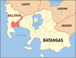
Balayan est une municipalité des Philippines située dans la province de Batangas, sur l'île de Luçon. Au recensement de 2020, elle avait 95 913 habitants.
Barangays
La municipalité est divisée en 48 barangays (districts) :
- Baclaran
- Barangay 1 (Pob.)
- Barangay 2 (Pob.)
- Barangay 3 (Pob.)
- Barangay 4 (Pob.)
- Barangay 5 (Pob.)
- Barangay 6 (Pob.)
- Barangay 7 (Pob.)
- Barangay 8 (Pob.)
- Barangay 9 (Pob.)
- Barangay 10 (Pob.)
- Barangay 11 (Pob.)
- Barangay 12 (Pob.)
- Calan
- Caloocan
- Calzada
- Canda
- Carenahan
- Caybunga
- Cayponce
- Dalig
- Dao
- Dilao
- Duhatan
- Durungao
- Gimalas
- Gumamela
- Lagnas
- Lanatan
- Langgangan
- Lucban Pook
- Lucban Putol
- Magabe
- Malalay
- Munting Tubig
- Navotas
- Palikpikan
- Patugo
- Pooc
- Sambat
- Sampaga
- San Juan
- San Piro
- Santol
- Sukol
- Tactac
- Taludtud
- Tanggoy
Notes et références
 Portail de la géographie
  Portail des Philippines