District de Reutte
| Reutte | |
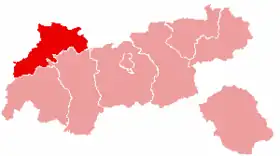 Localisation du district de Reutte dans le Land autrichien de Tyrol. | |
| Administration | |
|---|---|
| Pays | |
| Land | |
| Centre administratif | Reutte |
| Immatriculation | RE |
| Démographie | |
| Population | 32 023 hab. () |
| Densité | 26 hab./km2 |
| Géographie | |
| Coordonnées | 47° 24′ nord, 10° 30′ est |
| Superficie | 123 682 ha = 1 236,82 km2 |
| Localisation | |

Le district de Reutte est une subdivision territoriale de l'État du Tyrol en Autriche.
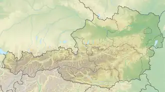
Géographie
Lieux voisins
Communes
Le district comporte 37 communes :
- Bach
- Berwang
- Biberwier
- Bichlbach
- Breitenwang
- Ehenbichl
- Ehrwald
- Elbigenalp
- Elmen
- Forchach
- Grän
- Gramais
- Häselgehr
- Heiterwang
- Hinterhornbach
- Höfen
- Holzgau
- Jungholz
- Kaisers
- Lechaschau
- Lermoos
- Musau
- Namlos
- Nesselwängle
- Pfafflar
- Pflach
- Pinswang
- Reutte
- Schattwald
- Stanzach
- Steeg
- Tannheim
- Vils
- Vorderhornbach
- Wängle
- Weissenbach am Lech
- Zöblen
Carte interactive des communes du district de Reutte
Notes et références
Liens externes
- Sites officiels : (de + en + it) www.tirol.gv.at/bh-reutte et (de) www.tirol.gv.at/bh-reutte
 Portail de l'Autriche