District régional de Central Kootenay
| District régional de Central Kootenay | |
| Administration | |
|---|---|
| Pays | |
| Province | |
| Siège | Nelson |
| Démographie | |
| Population | 59 517 hab. (2016) |
| Densité | 2,7 hab./km2 |
| Géographie | |
| Superficie | 2 213 071 ha = 22 130,71 km2 |
| Localisation | |
| |
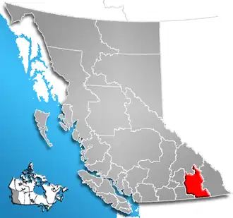
Le District régional de Central Kootenay en Colombie-Britannique est situé dans le sud-est de la province. Il est entouré par le district régional de Columbia-Shuswap au nord, par le district régional de Kootenay Boundary et le district régional de North Okanagan à l'ouest, par le district régional d'East Kootenay à l'est et par l'État de Washington au sud. Le siège du district régional se situe à Nelson.
Démographie
Villes principales
Routes principales
Routes principales traversant Central Kootenay:
- Highway 3 (Crowsnest Highway)
- Highway 6
- Highway 21
- Highway 22
- Highway 23
- Highway 31
- Highway 95
Références
Liens externes
 Portail de la Colombie-Britannique