Honington (Warwickshire)
Honington (Warwickshire)

| Pays | |
|---|---|
| Nation constitutive | |
| Région | |
| Comté non métropolitain | |
| District non métropolitain | |
| Superficie |
15,73 km2 () |
| Coordonnées |
52° 04′ 48″ N, 1° 36′ 54″ O |
| Population |
166 hab. () |
|---|---|
| Densité |
10,6 hab./km2 () |
| Statut |
|---|
Localisation sur la carte d’Angleterre
 |
Localisation sur la carte du Royaume-Uni
 |
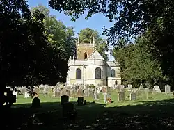
Honington est un village et une paroisse civile du Warwickshire, en Angleterre.
Notes et références
Liens externes
- Ressource relative à la géographie :
 Portail de l’Angleterre