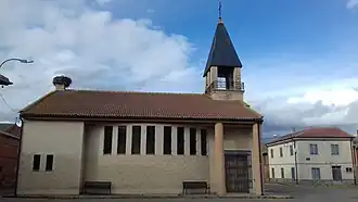
Villazala
Villazala
.svg.png)
.svg.png)
| Nom officiel |
(es) Villazala |
|---|
| Pays | |
|---|---|
| Communauté autonome | |
| Province | |
| Partie de | |
| Chef-lieu |
Villazala (d) |
| Superficie |
45,42 km2 |
| Altitude |
796 m |
| Coordonnées |
42° 21′ 40″ N, 5° 51′ 22″ O |
| Population |
596 hab. () |
|---|---|
| Densité |
13,1 hab./km2 () |
| Statut | |
|---|---|
| Chef de l'exécutif |
José Antonio Guerrero Villoria (d) |
| Contient les localités |
| Code postal |
24763 |
|---|---|
| INE |
24228 |
| Immatriculation |
LE |
| Site web |
(es) www.aytovillazala.es |
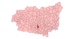
Localisation sur la carte d’Espagne
 |
Villazala est une commune d'Espagne dans la province de León, communauté autonome de Castille-et-León. Elle s'étend sur 45,42 km2 et comptait environ 749 habitants en 2015.
 Portail de Castille-et-León